|
|
||||
| |
|||||
|


 |
 |
 |
|
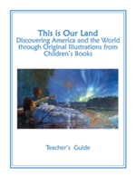
This is Our Land: Teacher's Guide
This guide offers gallery and classroom activities for museum educators, teachers, and docents. It emphasizes geography, map reading, and travel skills, and includes exercises designed to encourage young people to better understand their neighborhood, region, or state. "Looking" projects will strengthen students powers of observation and promote an appreciation of the visual arts. To view an illustrated list of works for This is Our Land please click here.
Cultural consultants from Meridians International Classroom program present information about their home countries to school children visiting the This is Our Land exhibition. For pictures click here.
As part of Meridian's effort to promote geographical literacy, we offer artistically rendered maps of the states and countries included in the exhibition. These include "fun facts" about each place and are designed to inspire students to create their own maps. In carrying out this activity, young people will gain an appreciation of our vast and remarkable world and the differences that characterize it. To view please click part one, part two, and part three of the maps.
The Teacher's Guide and Illustrated List are available in Adobe Portable Document Format format (.pdf). Please click on the link below to download the program Adobe Reader®.
|
 |
 |
 |
| | Meridian International Center | Arts at Meridian | Traveling Exhibitions | |